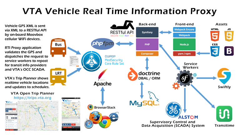
Real-time Vehicle GPS Applications Development
GPS Application Development
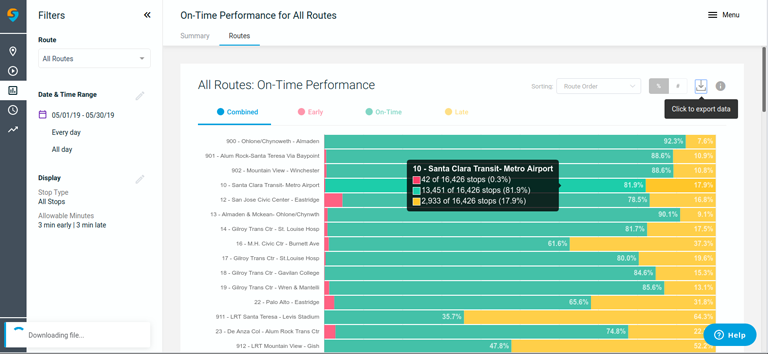
Directional Consulting has considerable experience working with GPS data, tracking devices, and GIS maps. Our expertise includes developing the RTVIP (Real-time Vehicle Information Proxy) for the Santa Clara VTA and their fleets of buses and light rail vehicles. The diagram to the left shows VTA vehicle routes and their early, on-time, or late arrival percentages.
Scalable Application Design
We leveraged a nice balance of performance and cost savings using today's standards like AWS auto-scaling groups. For example, the proxy group will auto-spin additional instances once latency and throughput thresholds are triggered. Then during off-peak hours and late at night when few vehicles are in transit, the group runs only one server.
Modern Design Pattern Principles
Incorporating traditional MVC frameworks with more modern Service and Event-driven architecture has proven to be very powerful in delivering robust applications. In addition, diversity and unity are vital in designing a solid integrated framework for real-time data interchange, display, and communications.
Integrated Services and Events
Directional Consulting is skilled at building data pipelines from various sources of data streams, including XML, JSON, CSV, MQTT, and HTTP response codes. Incorporating service event listeners in application design provides additional business logic layers to be implemented, modified, and easily updated without significant design changes.
Low Latency Application Design
The Transit mobile phone app used by thousands of San Fransisco Bay Area commuters daily relies upon Directional Consulting's design and deployment of a parallel background processing GPS proxy engine for the Santa Clara VTA. As a result, incoming GPS requests are immediately bounced within milliseconds to partner transit agencies like Transit, Google, and the MTA.
Used by thousands of Transit app commuters
The video to the left demonstrates the real-time video capture from my mobile phone while using the Transit app and the less than 2-second delay from the inbound light rail vehicle approaching the platform. Notice how the vehicle doors and the PID (Public Information Display) above the tracks synchronize to the precise moment the train arrives.
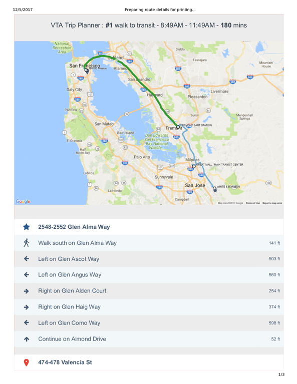
Trip Planning and Route Directions
Directional Consulting assisted Santa Clara VTA with upgrading its Open Trip Planner application for multi-modal transportation, meaning walking, bicycling, bus, and light rail routes, including bike trails and pedestrian bridges. The project centered around adding new vector overlays using Node.js and D3 graphing libraries, plus adding additional map options like Google and ESRI maps with terrain, roads, and satellite imagery.
Enhanced Printing and Email Directions
To address the needs of VTA customers without smartphones, Directional Consulting created additional Node.js and puppeteer routines to display and overlay the route on a map with a table of the turn-by-turn directions. Technically this feature took much work to achieve due to the nature of Google Maps. However, the knowledge gained is just one more feature option we offer clients.